City of Antioch Redistricting 2021
City Of Antioch Redistricting 2021
Elections Code section 21508 (g) of the FAIR MAPS Act requires the City of Antioch maintain a website for at least 10 years after the adoption of new City Council District boundaries.
Redistricting – Final Adopted Resolution No. 2022/51
The final Redistricting Map has been adopted on April 12, 2022. The two Council Member seats that are up for Election on November 8, 2022, are Districts 1 and 4 (both 4-year terms).
Steps to find your City Council District:
- Go to: www.antiochprospector.com
- Top Right: click on ‘Layers’
- Select ‘Antioch Council Districts’
- Left Column: Search by Address
Email redistricting@antiochca.gov with any questions about redistricting in the City of Antioch.
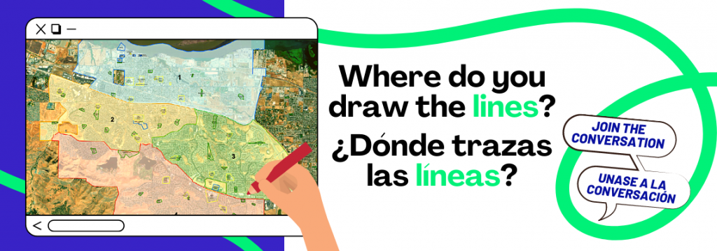
The City of Antioch is asking for your help to redraw new City Council districts!
Every ten years, local governments use new census data to redraw their district lines to reflect how local populations have changed. Assembly Bill 849 (2019) requires cities and counties to engage communities in the redistricting process by holding public hearings and/or workshops and doing public outreach, including to non- English-speaking communities.
The finalized maps that you will help us create will define the six City of Antioch district borders, and these new districts will impact how you elect your councilmembers for the next 10 years.
One criteria for developing election districts is to draw lines that respect neighborhoods and communities of interest. So we want to know: What do you consider the boundaries of your neighborhood? Who is your community, what brings you together, and where are you located?
- Tuesday, October 12, 2021 (Slideshow | Meeting Video)
- Saturday, October 16, 2021 – Public Workshop at 10:00 a.m. (Agenda | Slideshow | Meeting Video)
- Tuesday, November 9, 2021 – Public Hearing – Drawing and presentation of potential maps and community feedback (Agenda | Meeting Video)
- Tuesday, December 14, 2021 – Public Hearing – Drawing and presentation of potential maps and community feedback (Agenda | Meeting Video)
- Tuesday, January 11, 2022 – Public Hearing – Drawing and presentation of potential maps and community feedback (Agenda | Meeting Video)
- Tuesday, January 25, 2022 – Public Hearing – Drawing and presentation of potential maps and community feedback (Agenda | Meeting Video)
-
Tuesday, February 8, 2022 (Agenda | Meeting Video)
- City Council Special Meeting at 6:00 p.m. – Presentation of potential maps and community feedback
- City Council Regular Meeting at 7:00 p.m. – Public hearing with resolution adopting the final redistricting map Tabled
-
Tuesday, February 22, 2022(Agenda | Meeting Video)
- City Council Special Meeting at 6:00 p.m. – Presentation of potential maps and community feedback and selection of the final map or finalist maps
-
Tuesday, March 8, 2022(Agenda | Meeting Video)
- City Council Regular Meeting at 5:30 p.m. – Public hearing with resolution adopting the final redistricting map
-
Friday, March 11, 2022(Agenda | Meeting Video)
- City Council Special Meeting at 5:15 p.m. – selection of the final map or finalist maps
-
Tuesday, April 12, 2022(Agenda | Meeting Video)
- City Council Regular Meeting at 7:00 p.m. – Public hearing with resolution adopting the final redistricting map
For all City Council past meeting videos and agendas, visit: www.antiochca.gov/government/agendas-and-minutes/city-council/
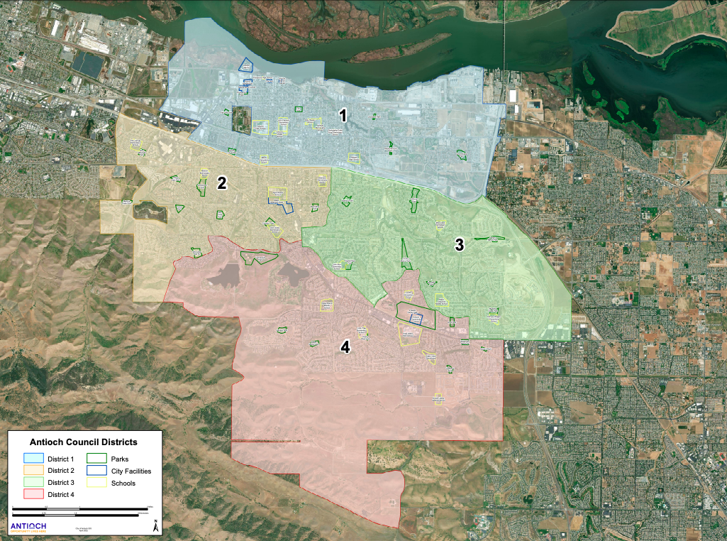
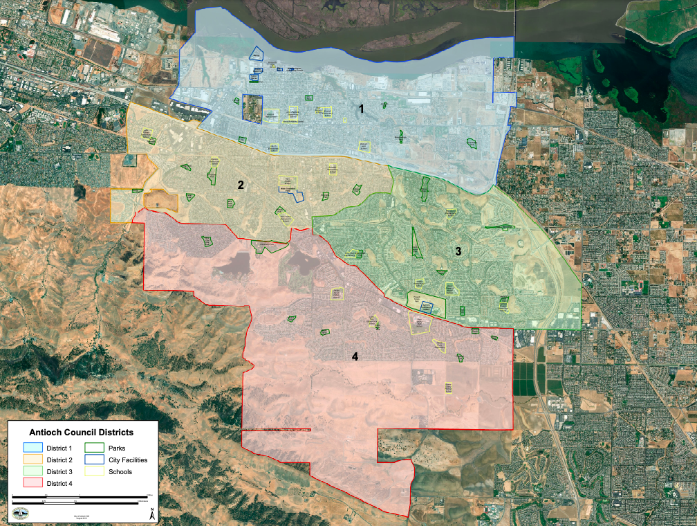
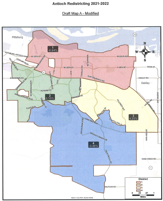
- District 1: Northernmost Council District. The western, northern, and eastern boundaries of this district are the city limits and the southern boundary is Highway 4.
- District 2: Boundary lines include Highway 4, Davison Drive, Hillcrest, Lone Tree Way, Delta de Anza, James Donlon Boulevard ,and Sommerville Road
- District 3: Eastern boundary is the city limits. Boundary lines include Highway 4, Lone Tree Way, Davison Drive, and Hillcrest Avenue.
- District 4: Southernmost Council District. Boundary lines include Sommerville Road, James Donlon Boulevard, Delta de Anza, Lone Tree Way.
A community of interest is a “contiguous population that shares common social and economic interests that should be included within a single district for purposes of its effective and fair representation.” Communities of interest are the overlapping sets of neighborhoods, networks, and groups that share interests, views, cultures, histories, languages, and values and whose boundaries can be identified on a map.
The following elements help define communities of interest:
- shared interests in schools, housing, community safety, transit, health conditions, land use, environmental conditions, and/or other issues;
- common social and civic networks, including churches, mosques, temples, homeowner associations, and community centers, and shared use of community spaces, like parks and shopping centers;
- racial and ethnic compositions, cultural identities, and households that predominantly speak a language other than English;
- similar socio-economic status, including but not limited to income, home-ownership, and education levels;
- shared political boundary lines from other jurisdictions, such as school districts, community college districts, and water districts.
What is the nature of the bond or common interest of your community?
Please describe what the common interests of your community are, and why or how they are important. For example:
- If your Community of Interest is built around a community center, then your testimony should include the name and location of the center and describe the community’s involvement in it or why it is important. You might say that the surrounding community accesses a variety of educational and recreational opportunities for children, adults and senior citizens at the center and that neighborhood meetings are held there.
- You may also identify a Community of Interest based on a shared culture or heritage of residents in a specific area. Please indicate why it is a common bond, e.g. “because of our shared history and language, we work together on cultural projects and this creates a sense of unity and understanding.”
Where is your community located?
Tell us where the exterior boundaries of your COI are so we can locate it on a map. For example, fill out the Antioch Written COI Form to write down landmarks, streets, bodies of water, or railroad tracks that indicate the location of the outside border of the community.
A map showing the location of the COI, along with oral or written testimony identifying the location, can be extremely helpful to locate the COI. Please see our instructions for “How to Create Your Community of Interest Online”.
Email your Antioch Written COI Form to Redistricting@antiochca.gov
Why is it beneficial for your community to be kept together in a district?
When you talk about your Community of Interest, consider explaining why it should be kept together in a district and why splitting it would be problematic. For example:
- A Community of Interest working on creating economic opportunities might note that redevelopment and job creation activities are more effective when residents in the respective area can work together with one, rather than multiple representatives.
- A small COI that is working to receive government support may find that it has lesser chances of receiving funding if split into two.
- Antioch Redistricting Public Map #11162021449
- Antioch Redistricting Public Map #11212021458
- Antioch Redistricting Public Map #11282021434
- Antioch Redistricting Public Map #1152021439
- Antioch Redistricting Public Map #12142021487
- Antioch Redistricting Public Map #12142021491
- Antioch Redistricting Public Map #12172021495
- Antioch Redistricting Public Map #12202021499
- Antioch Redistricting Public Map #01102022503
- Antioch Redistricting Public Map #01242022508
- Antioch Redistricting Public Map #02082022512
- Antioch Redistricting Public Map #02082022516
- Antioch Redistricting Public Map #02142022521
On April 12, 2022 at the regular meeting of the Antioch City Council, the Council adopted a resolution with the final redistricting map adjusting and redefining the boundaries of the City Council electoral districts of the City.
American Community Survey (ACS): A survey that releases data in four broad categories every year. The categories are: social, demographic, economic and housing. The ACS replaced the ‘long form’ of the census that was collected once every 10 years. The ACS does not report counts of the population but rather estimates.
At-Large Election: In a jurisdiction (for example a city) with an at-large election system, all voters in the jurisdiction vote for all candidates running for office in that city. In at-large election systems, the candidates and office holders are eligible to hold office irrespective of where they live within the jurisdiction.
By-District Election: In a jurisdiction (for example, a city) with a by-district election system, the voters from each district vote for the candidates running for office in the voters’ respective district. Elected officials and candidates must also live in the district that they represent or want to represent.
California Voting Rights Act: The California Voting Rights Act of 2001 (CVRA), prohibits the use of an at-large election in a political subdivision if it would impair the ability of a protected minority group to elect candidates of its choice or otherwise influence the outcome of an election. The CVRA is different from the Federal Voting Rights Act (FVRA). Since the CVRA became law, many jurisdictions in California have changed from at-large to by-district elections.
Census Block: The smallest level of census geography used by the Census Bureau to report census data. In urban areas, census blocks usually conform to city blocks, and in rural areas they are often delineated by other physical features and legal boundaries such as bodies of water and roads. Redistricting is based on census block level data.
Census Tract: A geographic area for which the census bureau releases data. Census tracts are relatively permanent ‘units of analysis’ that are delineated for the purpose of presenting decennial census data. Census tracts usually contain between 2,500 and 8,000 people. Census tracts may be split by local jurisdictional boundaries. Census blocks nest in census tracts.
Citizen Voting Age Population (CVAP): A variable collected by the American Community Survey that is used in Voting Rights Act assessments. The population that is 18 years and older and a citizen of the United States.
Community of Interest: Group of people with one or more specific common interests. For redistricting, communities of interest are defined geographically based on where people with common interests live.
Compactness: Compactness often refers to a district’s shape and contours, focusing on how closely a district’s borders resemble a circle or square. When a district has ‘tentacles’ or oddly shaped borders, it is often said to be non-compact. In California, compactness in redistricting is defined as ‘not bypassing nearby population’ when constructing districts.
Contiguous OR Contiguity: A contiguous district is one in which all parts are geographically connected to each other in some way. Within a contiguous district, one may travel from any location to any other location without crossing the district boundary. Some districts are “water-contiguous” which means that islands have to be connected to the mainland; others are contiguous via a bridge. Drawing contiguous districts is applying the criterion of ‘contiguity.’ If districts are only connected at one point, they are not considered contiguous.
Cracking: A term used in Voting Rights that describes splitting significantly sized racial or ethnic communities into multiple districts, rather than keeping them together. Cracking is a particular problem when the division prevents the community from electing a candidate of its choice because it constitutes too small a portion of the electorate in the multiple districts.
Criteria for Redistricting: Rules established in the law that the redistricting body must follow when drawing electoral district boundaries. For example, one criterion is that districts have reasonably equal populations.
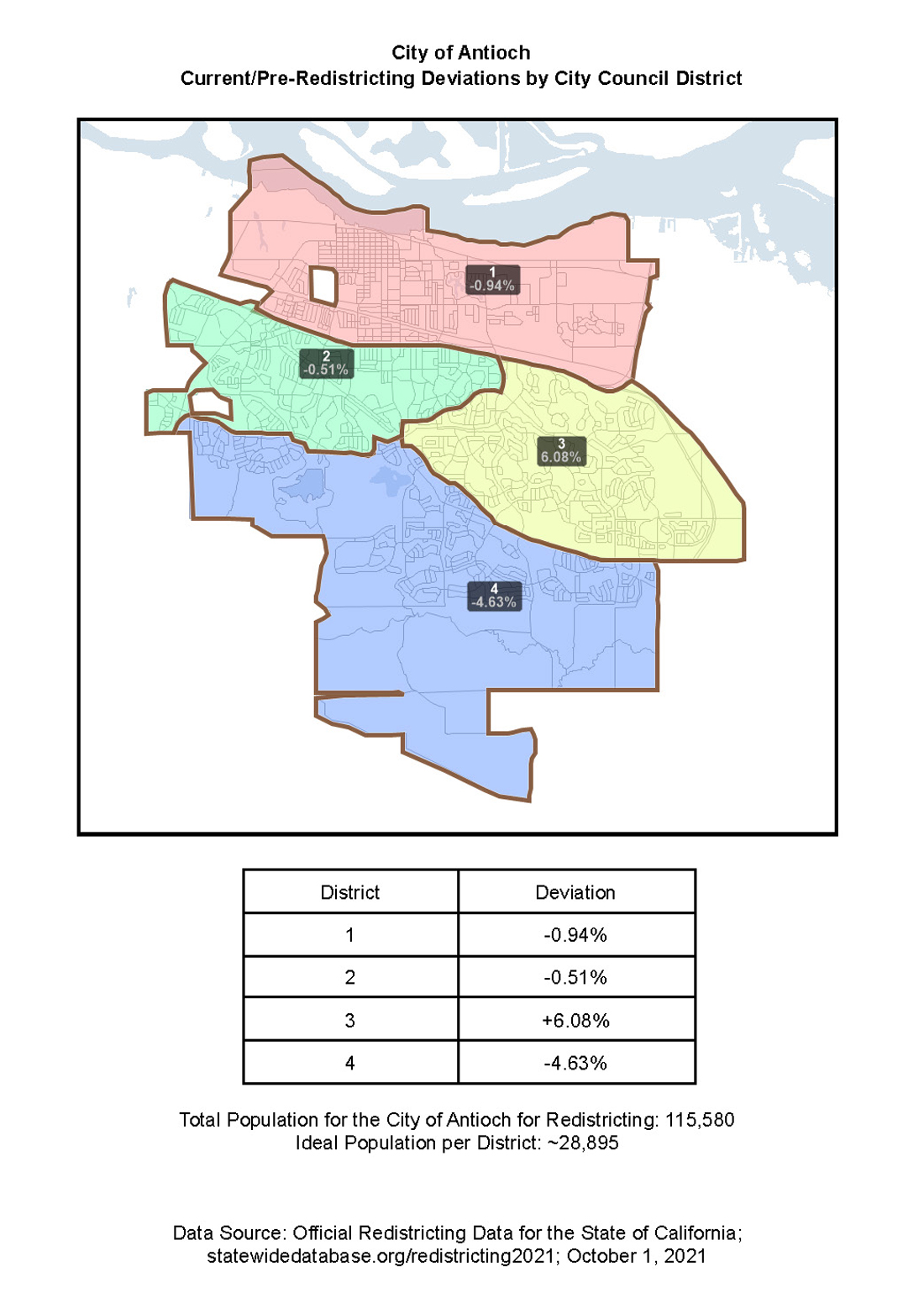
Deviation: The difference between the total population of the district and the ideal population of the district.
Districting: The process of creating equally populated electoral districts by using various criteria (such as Communities of Interest). In districting, electoral districts are created “from scratch” in a jurisdiction (a city for example) that does not currently have districts. Jurisdictions that do not have districts have “at-large” elections. Jurisdictions with districts redraw or adjust them (usually) every ten years after the release of the new census data to equalize the populations again. That process is called redistricting.
Equivalency File: A GIS file that shows the relationship between two geographic units. In redistricting, this file usually lists each census block in the dataset and indicates which district each block belongs to. The collection of block assignments is read by GIS software and displayed as district lines.
FAIR MAPS Act: Enacted in October 2019, the “Fair And Inclusive Redistricting for Municipalities And Political Subdivisions” is state law that addresses local redistricting for Cities and Counties in California. CA Elections Code Sections 21600 — 21609 specifically detail the process, criteria, and requirements for cities. The law increases transparency and public participation in the local redistricting process.
Geographic Information Systems (GIS) Software: A computer program for capturing, storing, checking, integrating, manipulating, analyzing and displaying data related to positions on the Earth’s surface. Examples of commonly used GIS software include Google Earth, ArcGIS, Maptitude and MapInfo.
Ideal Population: The total population for the jurisdiction as reported by the Census P.L 94-171 dataset divided by the number of districts. The ideal population is the number of people that each district should contain when the redistricting process is complete.
Map layer(s): GIS term for spatial/geographic data files as they are displayed by GIS software. Map layers may display attribute data. The term ‘map layer’ is sometimes used interchangeably with ‘spatial file’ and ‘GIS data file.’
Packing: A term used in Voting Rights that describes over-concentrating a significantly sized racial or ethnic community within one district when it could have been allocated between two or more districts in which would have had the ability to elect a candidate of its choice. Packing is a problem because over-concentrating a community in one district reduces or dilutes its ability to achieve fair representation in the legislative body in general.
Racially polarized voting (RPV) or racial bloc voting: Racially polarized voting occurs when voters of different races as a group tend to vote for different candidates. For example, in an area where white voters tend to vote against the candidates for which Asian American voters cast their ballots, racially polarized voting is present.
Reasonably Equal Population: The redistricting criterion that implements the one-person, one-vote concept derived from the 14th Amendment to the US Constitution.
Redistricting: The constitutionally mandated redrawing of local, state, and federal political boundaries every ten years following the U.S. census. Redistricting is done to equalize the populations in the districts, using various criteria.
Redistricting Data (P.L. 94-171) Summary File OR ‘P.L. 94-171 Summary File’: The official name of the file that contains data used for districting and redistricting. Creation of this file, using data collected through the Decennial Census was mandated by Public Law 94-171. The P.L. 94-171 file reports basic demographic data for all people in the U.S. and is released on the census block level.
Section 2 (of the Federal Voting Rights Act): Section 2 of the Voting Rights Act (VRA) prohibits voting practices, policies, or procedures that have a discriminatory purpose or effect on racial or language minorities; this section applies nationwide and is a permanent provision of the VRA. To be in compliance with Section 2 of the VRA districts must provide voters with an equal opportunity to elect candidates of their choice.
Total Deviation: The difference between the lowest and the highest deviation of all districts.
Voting Age Population (VAP): The number of people aged 18 years or older.
Voting Rights Act (VRA): The Voting Rights Act (VRA) was originally passed in 1965 to prohibit discrimination on the basis of race or color. It has been amended several times, and now also prohibits discrimination based on membership in certain language minority groups.
What is redistricting?
Redistricting is the constitutionally mandated redrawing of local, state, and federal political boundaries every ten years following the U.S. census. Redistricting is done to equalize the populations in the districts, using various criteria. In Antioch, these boundaries determine which neighborhoods and communities are grouped together into a district for purposes of electing Councilmembers.
What criteria will our city council use when drawing district lines?
- Compliance with the US and California Constitutions. This means that districts must have reasonably equal populations.
- Compliance with the Federal Voting Rights Act
- Geographically contiguous districts
- Minimize divisions of local neighborhoods or communities
- Boundaries should be easily identifiable and follow natural or artificial barriers
- Lines shall be drawn to encourage geographic compactness.
- Boundaries shall not be drawn for purposes of favoring or discriminating against a political party.
What are communities of interest (COI?
A community of interest is a “contiguous population that shares common social and economic interests that should be included within a single district for purposes of its effective and fair representation.” Communities of interest are the overlapping sets of neighborhoods, networks, and groups that share interests, views, cultures, histories, languages, and values and whose boundaries can be identified on a map.
What do the acronyms and categories mean on the demographic sheets?
Common acronyms demographic categories:
- NH: Non-Hispanic
- VAP: Voting age population
- CVAP: Citizen Voting Age Population
- CVRA: California Voting Rights Act
- FAIR MAPS Act: Fair And Inclusive Redistricting for Municipalities and Political Subdivisions
- NDC: National Demographics Corporation (the firm hired to produce the maps and provide demographic data)
Do we use the number of voters to draw districts?
Districts are drawn using the total population as counted by the last census. Everyone who was counted, irrespective of age, residency status or other demographics has to be assigned to a district. Districts are not equalized using voters, registered voters or citizens.
What Happens to The Drafted Maps?
After you submit your map, the demographic consultants will generate the population and other demographic details for your proposed map. Maps can be viewed on the Draft Maps page or on the Interactive Review Map. Once submitted, maps are considered public records.
Where Can I Learn More About Redistricting?
Online publications and guides to redistricting:
- District Elections Information
- From MALDEF, the NAACP and the Asian Justice Center
- From the Asian Americans Advancing Justice
- From the Brennan Center
- From the League of Women Voters
- From the California Independent Redistricting Commission FAQs
- From MALDEF, the NAACP and the Asian Justice Center
- From the Asian Americans Advancing Justice
- From the Brennan Center
- From the League of Women Voters
- From the California Independent Redistricting Commission FAQs
How can I get involved?
The City Council will seek input in selecting the next district map for electing Councilmembers. You have an opportunity to share with the City Council how you think district boundaries should be drawn to best represent your community either during the public hearings or by submitting comments to redistricting@antiochca.gov. We would like to hear from you so we can make informed decisions about where to draw district lines. Specifically, we need information from you about your neighborhoods and communities of interests. You are the expert who knows your community and neighborhood! If we know the geographic locations of the Communities of Interest in Antioch, we can consider them when drawing lines and we won’t inadvertently split them! Keeping communities together in the same district can help to get more responsive representation. You have an opportunity to share with the City Council how you think district boundaries should be drawn to best represent your community. You can contact the City Clerk’s Office at redistricting@antiochca.gov to find out more about how the process works.
How can I stay connected?
Please send any questions, comments, and map suggestions to redistricting@antiochca.gov; or contact the City by phone at (925) 779-7000.
Sign up to get automatic notifications of upcoming meetings! www.antiochca.gov/notifications/
Antioch City Clerk’s Office
Ellie Householder, City Clerk | Elections Official
Email: redistricting@antiochca.gov
Sign up for notifications: www.antiochca.gov/notifications/
Phone: 925-779-7009
Address: 200 H Street Antioch, CA 94509-1285
Mailing Address: P.O. Box 5007, Antioch, CA 94531-5007
2018 Districting Summary:
- Used a mapping program to construct districts after public input has been received.
- Census data used to find out how many people live in each part of the city and ensure that each district contains roughly the same number of people.
- Census geography used to ensure that the districts are compact and contiguous
- Collected and utilized Community of Interest data from the residents of Antioch to use in the building of districts.
Meetings:
- February 13, 2018; 7pm; Antioch Council Chambers, 200 H Street, Antioch, CA, 94509: Public Hearing 1 – Solicited public input
- February 15, 2018; 7pm; 4703 Lone Tree Way, Antioch, CA, 94531: Public Hearing 2 – Solicited public input
- March 10, 2018; 9am; Nick Rodriguez Community Center, 213 F Street, Antioch, CA, 94509: Public Hearing 3 – Reviewed maps and created a official Draft map
- March 27, 2018; 7pm; Antioch Council Chambers, 200 H Street, Antioch, CA, 94509: Public Hearing 4 – Read the Ordinance
- April 10, 2018; 7pm; Antioch Council Chambers, 200 H Street, Antioch, CA, 94509: Public Hearing 5 – Adoption of Ordinance and Districts
- May 8, 2018; 7pm; Antioch Council Chambers, 200 H Street, Antioch, CA, 94509: Public Hearing 6 – Antioch City Council voted to approve Ordinance No.2141-C-S to adopt by-district elections. The ordinance changes the election system in the City of Antioch from at-large to by-district elections for the City Council. This means that City Council members must live in the districts they represent, and will be elected by the voters in those districts starting with the 2020 election.
What happened at the public hearings in 2018? The hearings will be led by our districting consulting team are designed to be as accessible and transparent as possible. The hearings will have 3 phases. They will begin with a presentation to give an overview of the process and the criteria. After that, there will be an opportunity to mingle, study maps of the city and talk to the consultants and other residents to prepare input. Finally, the hearings will resume to allow for formal public input to be presented by attendees. The consultants will be able to show the area that the input focuses on using mapping software and a projector. The consultants will use the public input in constructing the draft maps.
Considerations made while drawing the Districts were drawn:
- Each district should contain nearly the same number of people;
- Boundaries shall be drawn in a manner that complies with the United States Constitution and the Federal Voting Rights Act;
- Council districts shall consist of contiguous territory in as compact form as practicable;
- Districts shall follow visible features and boundaries when possible;
- Council districts shall respect communities of interest as much as practicable. Communities of Interest generally refers to a contiguous population which shares common social and economic interests that should be included within a single district for purposes of fair and effective representation;
- The demographer will disregard the location of incumbents and candidates, as well as the interests of political parties.
2018 Timeline: The districting process timeline is prescribed by the California Election Code. Section 10010(b) requires that 2 hearings, no more than 30 days apart, are held prior to the development of a draft map. In order to enable resident participation in this process, the City is holding a third public hearing at which draft maps will be discussed and the council will have an opportunity to make changes to the maps live and in public. Two additional hearings, no more than 45 days apart, are required after a proposed map has been drawn. The entire process has to be completed within 90 days after the City council passed the resolution of intent.
As counted by the 2010 Census, the City of Antioch had a total population of 102,710. Because the decennial census is the only survey that counts everyone, we have to use those data to draw districts. There will be 4 council districts. To figure out the ‘ideal population’ for each council district, take the total population (102,710) and divide it by the number of districts (4) which equals 25,678 persons.
| Fact | Antioch, CA |
| Population, percent change – April 1, 2010 (estimates base) to July 1, 2016, (V2016) |
7.90% |
| Persons under 5 years, percent, April 1, 2010 |
7.10% |
| Persons under 18 years, percent, April 1, 2010 |
28.10% |
| Persons 65 years and over, percent, April 1, 2010 |
8.80% |
| Female persons, percent, April 1, 2010 | 51.30% |
| Veterans, 2012-2016 | 5,487 |
| Foreign born persons, percent, 2012-2016 |
21.90% |
| Housing units, April 1, 2010 | 34,849 |
| Owner-occupied housing unit rate, 2012-2016 |
60.80% |
| Median value of owner-occupied housing units, 2012-2016 |
$291,400 |
| Median gross rent, 2012-2016 | $1,439 |
| Households, 2012-2016 | 33,976 |
| Persons per household, 2012-2016 | 3.18 |
| Living in same house 1 year ago, percent of persons age 1 year+, 2012-2016 |
83.70% |
| Language other than English spoken at home, percent of persons age 5 years+, 2012-2016 |
34.20% |
| With a disability, under age 65 years, percent, 2012-2016 |
11.50% |
| Persons without health insurance, under age 65 years, percent | 10.20% |
| In civilian labor force, total, percent of population age 16 years+, 2012-2016 |
62.90% |
| In civilian labor force, female, percent of population age 16 years+, 2012-2016 |
59.00% |
| Mean travel time to work (minutes), workers age 16 years+, 2012-2016 |
45.2 |
| Median household income (in 2016 dollars), 2012-2016 |
$65,530 |
| Per capita income in past 12 months (in 2016 dollars), 2012-2016 |
$26,385 |
| Persons in poverty, percent | 14.30% |
| Population per square mile, 2010 | 3,611.10 |
| Land area in square miles, 2010 | 28.35 |
| FIPS Code | “0602252” |
| NOTE: FIPS Code values are enclosed in quotes to ensure leading zeros remain intact. |
|
Districting Working Draft District Demographics (2018)
| Working Draft: Quadrants B |
||||||||||
| District ID | %Deviation | %Latino | %White | %Black | %Asian | %Total CVAP |
%LatinoCVAP | %WhiteCVAP | %BlackCVAP | %AsianCVAP |
| A | 2.57% | 40.99% | 35.91% | 13.81% | 4.13% | 60.47% | 29.84% | 45.81% | 16.73% | 5.53% |
| B | -2.06% | 30.83% | 43.63% | 13.11% | 6.58% | 64.08% | 20.97% | 52.14% | 16.69% | 7.81% |
| C | 3.19% | 25.98% | 31.27% | 20.48% | 15.76% | 73.05% | 25.04% | 33.13% | 25.55% | 12.99% |
| D | -3.70% | 28.83% | 32.16% | 18.98% | 13.77% | 64.51% | 22.95% | 34.79% | 22.15% | 17.48% |
| Working Draft: Quadrants A |
||||||||||
| District ID | %Deviation | %Latino | %White | %Black | %Asian | %Total CVAP |
%LatinoCVAP | %WhiteCVAP | %BlackCVAP | %AsianCVAP |
| A | 4.78% | 42.34% | 32.83% | 15.56% | 4.14% | 60.33% | 29.00% | 41.96% | 19.54% | 7.00% |
| B | -3.33% | 31.87% | 42.88% | 12.87% | 6.55% | 63.22% | 21.10% | 52.12% | 16.97% | 7.58% |
| C | 1.74% | 26.31% | 28.98% | 22.06% | 16.15% | 71.74% | 25.52% | 30.14% | 27.04% | 13.59% |
| D | -3.19% | 25.69% | 38.69% | 15.74% | 13.54% | 67.11% | 23.01% | 42.10% | 17.57% | 15.40% |
| Working Draft 1 |
||||||||||
| District ID | %Deviation | %Latino | %White | %Black | %Asian | %Total CVAP |
%LatinoCVAP | %WhiteCVAP | %BlackCVAP | %AsianCVAP |
| A | -0.61% | 24.99% | 30.41% | 20.23% | 17.48% | 67.24% | 20.45% | 30.79% | 26.22% | 18.67% |
| B | -1.00% | 41.60% | 36.12% | 13.96% | 2.95% | 60.31% | 25.02% | 48.41% | 20.04% | 3.95% |
| C | 0.03% | 34.21% | 42.48% | 12.64% | 5.73% | 64.57% | 27.38% | 50.87% | 11.61% | 8.01% |
| D | 1.57% | 26.16% | 33.78% | 19.55% | 13.96% | 70.04% | 26.01% | 35.67% | 23.73% | 12.60% |
| Working Draft 2 |
||||||||||
| District ID | %Deviation | %Latino | %White | %Black | %Asian | %Total CVAP |
%LatinoCVAP | %WhiteCVAP | %BlackCVAP | %AsianCVAP |
| A | 0.43% | 25.00% | 27.25% | 22.32% | 18.30% | 66.00% | 21.33% | 28.94% | 28.14% | 18.02% |
| B | -1.00% | 41.60% | 36.12% | 13.96% | 2.95% | 60.31% | 25.02% | 48.41% | 20.04% | 3.95% |
| C | -0.46% | 34.09% | 40.97% | 12.78% | 6.93% | 65.18% | 29.28% | 45.76% | 12.64% | 10.25% |
| D | 1.02% | 26.32% | 38.49% | 17.30% | 11.89% | 70.68% | 23.42% | 41.94% | 21.08% | 11.24% |
| CVAP = Citizen Voting Age Population |
||||||||||
| Estimates were rounded and therefore the detail may not exactly add to the total |
||||||||||
| Data Sources: |
||||||||||
| (1) | ||||||||||
| 2010 Census Redistricting Data [P.L. 94-171] Summary File, U.S. Census Bureau |
||||||||||
| (2) | ||||||||||
| Citizen Voting Age Population (CVAP) Special Tabulation from the 5-Year |
||||||||||
| American Community Survey, U.S. Census Bureau |
||||||||||
2020 City Council District Schedule: districts 1 and 4 elected council members for initial two-year terms. These districts will be up for reelection again in 2022, and after that every four years. Districts 2 and 3 will elect members for four-year terms in 2020 and continue to do so every four years thereafter. This is done to preserve staggered elections, i.e. to ensure that two seats are open every two years. The mayor’s position is not affected by district elections and will continue to be elected at-large, by all registered voters in Antioch.
July 27, 2021: Redistricting Process And Community Outreach For City Council Member District Boundaries – City Attorney Smith and Karin Mac Donald representing Q2 Data & Research, LLC, presented the staff report and PowerPoint presentation dated July 27, 2021 (view PowerPoint) recommending the City Council provide direction to staff regarding the 2021-2022 Redistricting process and Community Outreach for City Council Member District Boundaries, including consideration of the following options: 1) City Council led Redistricting process (view agenda)
September 23, 2021: Official Redistricting Data Base for the State of California would be released.
Redistricting public meetings and hearing:
- Tuesday, October 12, 2021
- Saturday, October 16, 2021
- Tuesday, November 9, 2021
- Tuesday, December 14, 2021
- Tuesday, January 11, 2022
- Tuesday, January 25, 2022